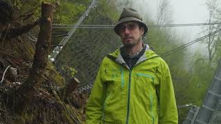
The western slopes of the mountain Schoberstein as part of the Höllengebirge pose a high risk of rockfall. These hazards are easily visible due to numerous boulders dumped in the forest and near houses and infrastructure. The neighborhoods of Weißenbach am Attersee, Forstamt, Gmauret and the main road along the lakeshore are within the risk zone.
The western slopes of the mountain Schoberstein as part of the Höllengebirge pose a high risk of rockfall. These hazards are easily visible due to numerous boulders dumped in the forest and near houses and infrastructure. The neighborhoods of Weißenbach am Attersee, Forstamt, Gmauret and the main road along the lakeshore are within the risk zone.
As part of the SCHOBERSTEIN 2021 hazard management project many measures will be implemented to increase the protection against natural hazards:
• Rockfall protection nets with a total length of 1,585 meters divided into 17 individual rows
• Rockfall protection dam with a length of 295 meters
• Management of the protective forest: afforestation, planting, thinning and maintenance operations
• Hunting and wildlife management and monitoring measures
The project covers an area of 302 hectares. During the period from 2021 to 2050 a total of € 6.5 million will be invested to protect our living and economic space.
-

© kopfsache zoom gallery -

© kopfsache zoom gallery
The rockfall protection nets ensure that rocks and boulders do not reach the settlements in the case of particularly high intensity events.
Protective forest management and technical measures in a combined way provide sustainable protection against natural hazards.

